


Improved map colors!
The pioneer in satellite oceanography, Ocean Imaging has been providing oceanographic and weather information to fishers and scientific researchers since 1983. Now our powerful worldwide SeaView fish finding service has gone mobile! SeaView Mobile delivers ready-to-use oceanographic analysis products including cloud-free sea surface temperature (SST) imagery, more single-satellite-overpass SST data than anyone, the highest resolution SST and chlorophyll imagery as well as sea surface height anomaly, ocean currents and much more! All to save you fuel, time and money while helping improve your fishing strategy right from your mobile device. Time-tested, most accurate SeaView Fishing data now at your fingertips.
Browse, download and view the latest information faster than any other service. Some SeaView Mobile images posts as fast as 30 minutes from the satellite data acquisition! Use the app both online and offline to view and navigate with the most frequent and accurate data available.
- High resolution (1100 meter) single-satellite-pass sea surface temperature (SST) data - updated 4-12 times per
- Super High Resolution (750 meter) SST imagery – updated 1-2 times per day
- Composite SST imagery to help reduce cloud contamination - updated daily
- Two types of cloud-free SST imagery - updated daily
- High resolution (1100 meter) single-satellite-pass plankton chlorophyll) imagery - updated daily from two different satellites
- Super high resolution (750 meter) chlorophyll imagery – updated daily
- Composite chlorophyll imagery to help reduce cloud contamination - updated daily
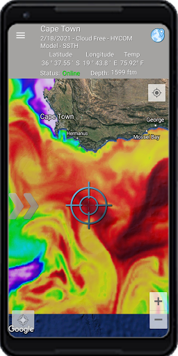
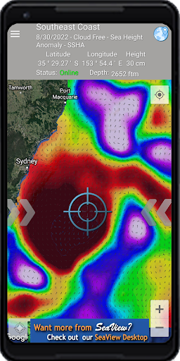
- U.S. NOAA sea surface height anomaly (SSHA) data - updated daily
- U.S. Navy HYCOM model sea surface height (SSH) data - updated daily
- U.S. NOAA SSHA-derived geostrophic ocean current data - updated daily
- U.S. Navy HYCOM model-derived ocean current data - updated daily
- High Frequency Radar-derived ocean currents – very accurate – updated daily (where available)
- Ocean bottom topography (bathymetry)
Powerful In-App Features:
- Custom color-enhance the image data to bring out the most detail and useful information
- Save image and overlay data to your device for future offline use
- Precise latitude, longitude location display
- See and read bathymetry either as your base layer or through semi-transparent imagery
- View your current location and track your GPS location over the image data or the bathymetric base layer
- Range and bearing from your GPS location
- View ocean currents over the image data or the bathymetric base layer
- More data and features coming soon!
Coverage areas around the world! If you don't see your region covered, email us at [email protected] and we'll work to get your area in SeaView mobile as soon as possible.

